


Field Report of an oxbow lake in Sersa, Haryana
This field report investigates the possibility of an oxbow lake in Sersa, Haryana. It provides satellite and on-site evidence for the lake’s existence. Oxbow lakes are formed when a river meanders and a part of it separates from the stream of the river to form a ‘U’ shaped curve. In the Gangetic Plain of Northern India, the perennial rivers are susceptible to the phenomenon of oxbow lakes, especially in Uttar Pradesh and Haryana1. In Uttar Pradesh, such lakes have prehistoric settlements in their vicinity. This cannot be confirmed in the case of Sersa but in the future, it is worth exploring for assessing its archaeological potential. The team for the reconnaissance consisted of Aneesh Sriram, Saketh Sundar and Tejas Nageshwaran of Ashoka University.
Geographic and Topographic Background
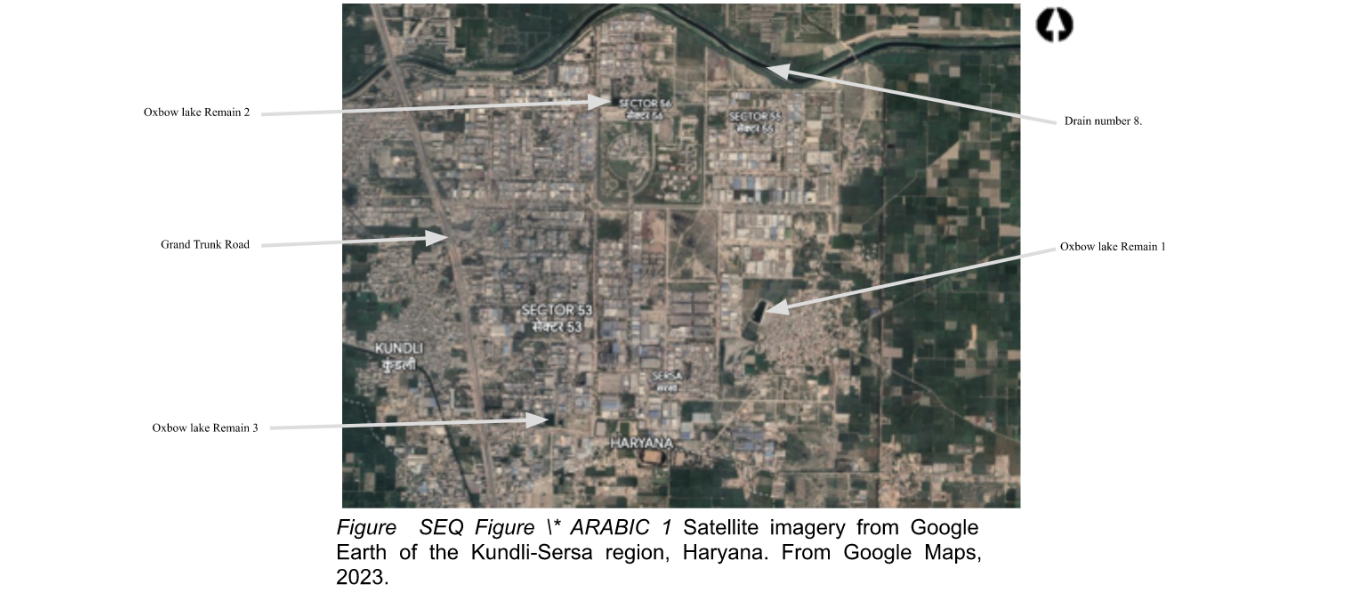
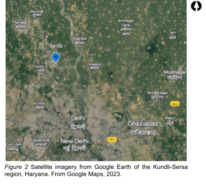
The site being considered in this report is known as ‘Sersa’ adjacent to the Kundli Industrial Area in the HSIIDC (Haryana State Industrial & Infrastructure Development Corporation) layout in Sonepat. The region of Sersa Kundli is in the Sonipat tehsil of Sonipat district in Haryana. It is situated in the Indo-Gangetic flood plain and located approximately 7 kilometres west of the Yamuna. The village is off the Delhi-Karnal Grand Trunk Road in the east. The broad coordinates of the location are 28.8662° N, and 77.1356° E. The lake itself lies between the coordinates 28.88233938081996 N, 77.13197237724631 E and 28.88231260194199 N, 77.1347577410583 E in the East-West alignment. Figure 1 and 2 depicts the extent of the site under consideration. The soil in this area is characteristic of an alluvial plain consisting of silty loam and is yellowish brown in colour. There is a presence of moderate organic matter on the surface with scrub occupying the empty lands of Sersa.
Today, the adjoining areas of the water body are occupied by factories and industrial areas involved in primarily iron and steel manufacturing, leather and garments, and electronics. As a result, most of the barren or empty land has been occupied for construction. However, amidst the industrial complexes, there exists the Sersa Lake – a segment of the erstwhile oxbow lake. The land on the banks of the lake has undulating ground features with some bank erosion. Organic matter including recent animal bones, grass, dung, algal matter, and inorganic matter such as domestic household waste are present in the area surrounding the lake. Modern settlements also adjoin the lake with limited land to conduct a survey. Broadly speaking, two exposed segments which are the remnants of the otherwise encroached oxbow lake could be isolated which will be examined further in the report. In addition, the report looks at a plot of land approximately 700 meters northwest of oxbow lake Remain 1 and the banks of Drain Number 8 running in the east-west direction to the north of oxbow lake Remain 2.
Archaeological and Historical Background
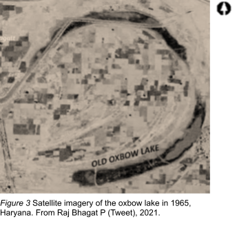
The credit for drawing attention to its presence goes to a Twitter user by the name of Raj Bhagat P in 2021. Bhagat’s surmise was based on data from CORONA (NARA-USGS) imagery, and that image is reproduced here, clearly revealing the demarcation of the lake as it appeared in 1965 (Figure 3). He was of the opinion that this represented an old meander of the Yamuna River.
Apart from a mention of the possible presence of a lake, no other further research has been conducted on the field or mapping the lake in the present times. As to the actual age or timeline of the formation of the lake, more information in the form of oral histories, archives of the Survey of India, and on-field research is crucial as the extent of satellite imaging is limited. Archaeology in the state of Haryana has been promising. However, a pattern observed among the distribution of sites is its scattered nature and the minimal representation of south-eastern Haryana, specifically Sonipat. Thus, the following sections will demonstrate how the lake has evolved through the years between 2000 and 2022 in terms of modern settlements, vegetation cover, and overall surface area of the lake. Through this we may be able to determine the presence of such sites in the Sonipat district of Haryana. Prior to the occupation by the industries of the HSIIDC in Kundli, the region was primarily agricultural land with dry deciduous trees bordering the perimeter of the lake.
Methodology
Before doing a ground survey, data was collected using Google Earth Satellite imagery. The imagery displays no presence of an oxbow lake if looked at from a larger scale of the map. Nevertheless, the remnants of the lake are visible if the scale of the imagery is reduced to only focus on the water body and the areas surrounding it. Before undertaking an on-site visit, Google Earth Street View was used to discern the viability of exploring the location. Queries including the accessibility of the site, distance, general land use, and spatial information were gathered before visiting the site in person. Google Earth’s Street View served a crucial purpose and the prudent use of it could be of great assistance for future research.
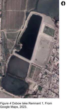
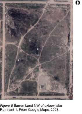
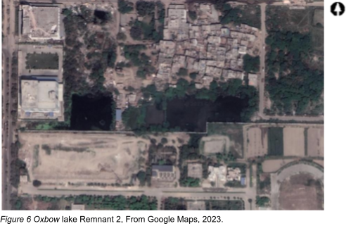
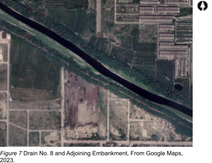
The field visit was conducted on the 24th of February 2023. With the help of the satellite map, the exploration started at Oxbow Lake Remnant 1 as shown in Figure 4. An unsystematic walk was conducted on the banks of the lake to survey for any changes in soil patterns. In addition, the ground was scrutinized to identify any surface-level artefacts. Following this, the barren land to the northwest of the site was also visited. The piece of land is shown in Figure 5. The surface of the land was scanned to look for any clues marking historical settlements in this region. The soil here was primarily sandy due to the construction work taking place not far from the area surveyed. Oxbow Lake Remnant 2, shown in Figure 6, was also visited. The area leading up to the bank of the lake appears to be inaccessible. What one can observe however is the patches of land which lead to this lake, which are undoubtedly the old course of the curved shape of the lake. Today, these patches are covered by vegetation and grasses, this is due to high moisture content in the area. A phenomenon called positive crop mark2. Finally, to the northeast of the Oxbow Lake Remnant 2 runs Drain Number 8. The embankment of this drain was visited. The drain itself is non-perennial and was dry at the time the survey was conducted. This feature is shown in Figure 7.
Photographs of the features were taken to record their state and have been presented in the next section. Walk-over surveys were used to discern which features to photograph for this report.
Results and Discussion
The results the site has produced are promising as on-site observation proves the existence of both the remnants of the oxbow lake. In addition to the imagery provided by Bhagat on the lake in 1965, the evolution of the lake from 2000 to 2015 has been provided in Figure 8. One can see in the figure the outline of the lake and how that has transformed the landscape through the snapshot.
The on-site visit confirmed that oxbow lake is quite visible in both locations depicted on the satellite map. On first impression, the region surrounding the lake is empty with grass and continues to be a rich biodiversity spot for birds and a few fish. Some parts of the lake have dried up and have either been occupied by settlements, industry, or weeds. The banks of the river demonstrate sedimented water erosion. The bank of oxbow Lake Remain 1 has been shown in Figure 9 and the lake itself is shown in Figure 10. Oxbow Lake remnant 1 lies between 28.868679729871157 N, 77.14073326158915 E and 28.87087784516687 N, 77.1418831380538 E, in the North-South Orientation. It has a size of 17,457.51 m².
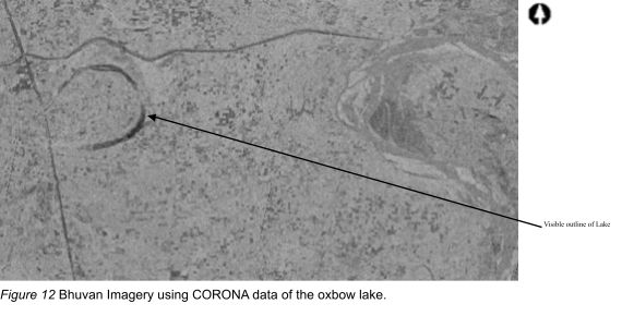
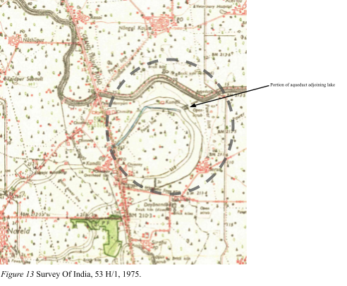
In addition, with the assistance of Dr M.B. Rajani, Associate Professor, School of Humanities, NIAS, data from Bhuvan (CORONA imagery) and Survey of India Topo sheet 53/H1 1977 1st edition, have been consulted which have yielded positive results indicating a clear demarcation of an Oxbow Lake. The CORONA imagery of the larger region is retrieved from Bhuvan is shown in Figure 12. The survey sheet of 1975 has been reproduced in Figure 13. In this survey sheet, indications of a dry water body have been shown in the shape of an oxbow. This location matches with the current position of the remains of the lake. In addition, toward the northern and north-western portions of the lake, we are able to discern from the survey map that these portions were in active use during the duration of the survey. This portion, depicted in blue on the map, also demonstrates a topography consistent with the path of the lake.
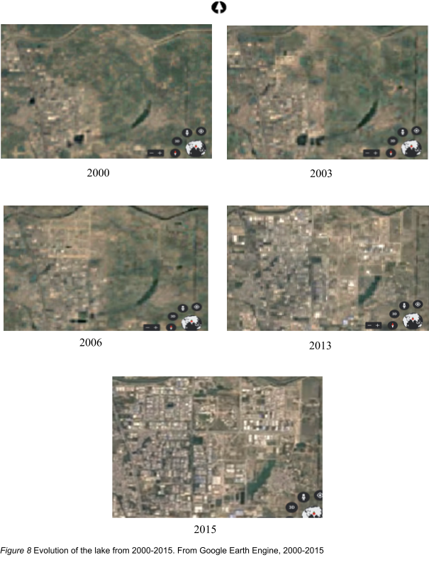
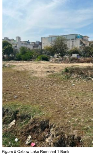
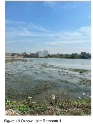
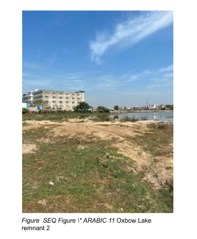
Figure 11 shows the remnant of the oxbow lake on the NW of Oxbow Lake Remain 1 in another location with the coordinates 28.88233938081996 N, 77.13197237724631 E and 28.88231260194199 N, 77.1347577410583 E in the East-West alignment. The size of this remaining is 13,895.65 m². The existence of these lakes in the site coupled with satellite imagery and archival evidence corroborates the presence of an erstwhile oxbow lake with a few sectionals’ remnants in Sersa, Kundli. A perceptive observer would notice traces of an aqueduct connecting the Drain Number 8 and the oxbow lake next to remnant 2. This feature cannot be observed distinctly in the modern map projection. Using the CORONA imagery, Google Earth Engine and Topographic Survey map of 1975, the feature is visible which follows the old course of the lake pattern. The remnant of the aforementioned aqueduct is shown in Figure 13 with an arrow.
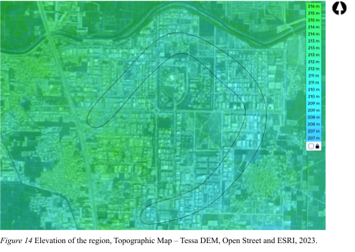
Elevation is an important marker to depict the topology of an area. A relatively lower height would suggest a path the lake would have followed in the past. With the help of a Digital Elevation Model dataset on ESRI imagery, the path of a lower elevation level has been shown to be in the shape of the oxbow lake. This would indicate the clear presence of the lake shown to be at a lower elevation in comparison to the general land elevation. This path is shown in shades of blue in Figure 14.
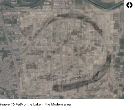
To determine the path of the lake today, the image of the old lake when it existed was superimposed on the modern map of Sersa and Kundli to scale. This is shown in Figure 15 – depicting the shape of the lake, which would have emerged from the old course of the Yamuna.
Artefacts were searched for on the surface, but due to excessive water damage and human settlement, none were found. The presence of industries only a few meters away from the banks of the lake puts both the biological ecosystem and archaeological context at risk. It can be predicted with certainty that no archaeological study was conducted before the construction of these industries. Thus, a large amount of valuable information and data possibly would have been lost through the years of the growth of Kundli town. However, this report recommends further exploration of the barren areas surrounding the lakes. A reconstruction of the paleo-botanical environment can also be conducted, as done by Thornbush and Desloges in Canada3. A coring of available spots near the oxbow lake in Sersa Kundli is recommended. This would offer insights into the environment around the lake dating back to the formation of the lake. It will also be one of the first studies of an oxbow lake of the Yamuna in this region and provide crucial information on relict botanical and faunal remnants. Finally, further study in this area might also offer explanations to the historic context of the Haryana region in the flood plain area.
- Chattopadhyaya had conducted a study on Mesolithic settlements around Oxbow lakes in Sarai Nahar Rai and Mahadaha and identified faunal and human remains in these sites (1996).
- Areas where ditches, pits and other features have been dug into the subsoil become filled over time. This relative increase in soil depth and the potential to provide increased soil moisture enables the crops above to grow higher and ripen later than the plants around them, producing ‘positive cropmarks’ (arcland.eu).
- This coring study was able to “reconstruct the impact of base level on fluvial stability and human occupation during the Holocene in a topographically confined section” (2013).
Acknowledgment:
Author: Aneesh Sriram, Ashoka University
Overall Guidance – Prof. Nayanjot Lahiri (Ashoka University).
Assistance on Satellite Imaging – Prof. M.B Rajani (NIAS).
Team for On-site Reconnaissance – Tejas Nageshwaran (Ashoka University) and Saketh Sundar (Ashoka University).
General information on Oxbow lake paleo-settlement patterns – Prof. Kalyan Sekhar Chakraborty (Ashoka University) and Prof. Sanjukta Datta (Ashoka University).
Editing – Prof. Nayanjot Lahiri (Ashoka University), Prof. M.B Rajani (NIAS), Prof. Kalyan Sekhar Chakraborty (Ashoka University).
References
Bhagat, P [@rajbhagatt]. (2021, February 8). Forgotten history of a lake [Tweet]. Twitter. https://twitter.com/rajbhagatt/status/1366004043202498561?ref_src=twsrc%5Etfw%7Ctwcamp%5Etweetembed%7Ctwterm%5E1366004043202498561%7Ctwgr%5E%7Ctwcon%5Es1_&ref_url=notion%3A%2F%2Fwww.notion.so%2FExploration-and-Archaeological-Investigation-Plan-e5c064e9cda840e697c4cec4318df128
Bhuvan. (n.d.). CORONA Imagery | Bhuvan. Bhuvan – Indian Geo-platform for ISRO. https://bhuvan.nrsc.gov.in/home/index.php
Chattopadhyaya, U. C. (1996). Settlement Pattern and the Spatial Organization of Subsistence and Mortuary Practices in the Mesolithic Ganges Valley, North-Central India. World Archaeology, 27(3), 461–476. http://www.jstor.org/stable/124936
Dieras, Pauline L. “The Persistence of oxbow lakes as Aquatic Habitats: An Assessment of Rates of Change and Patterns of Alluviation.” 2013.
Google Maps Satellite Imagery. (1998-2023). [Kundli-Sersa]. Retrieved February 2023, https://www.google.com/maps/place/Sersa+Kundli,+Delhi,+Haryana+131028/@28.8668457,77.1266282,15z/data=!3m1!4b1!4m6!3m5!1s0x390dab9f5b148f49:0xca99f426f78695d!8m2!3d28.8661842!4d77.1355733!16s%2Fg%2F1thcl4l5
Pal, Dr Swades. “A Journey toward oxbow lake Formation and Associated Change in Human Mosaic: Study on Kalindri River of Malda District.” IOSR Journal of Humanities and Social Science, vol. 5, no. 6, 2012, pp. 32–39., https://doi.org/10.9790/0837-0563239.
Paul, Rajan. “Temporal Change Assessment of oxbow lakes in Kerala, India Using Geographic Information System.” International Journal of Science and Research (IJSR), vol. 5, no. 6, 2016, pp. 294–297., https://doi.org/10.21275/v5i6.nov164046.
rvey of India. 53 H/1. Open Map Series. Dehradun: Survey of India, 1975.
Topographicmap.com. Tessa DEM, Open Street and ESRI Imagery. 2023, https://en-gb.topographicmap.com/map/?center=28.87001%2C77.13424&zoom=14&base=5&popup=28.8736%2C77.15387